icon for Home page
icon for Kid's Home page
icon for Digital Collection
icon for Activities
icon for Turns Exhibit
icon for In the Classroom
icon for Chronologies
icon for My Collection

Things To Do
Dress Up | 1st Person | African American Map | Now Read This | Magic Lens | In the Round | Tool Videos | Architecture | e-Postcards | Chronologies | Turns Activities

Send an E-Postcard of:
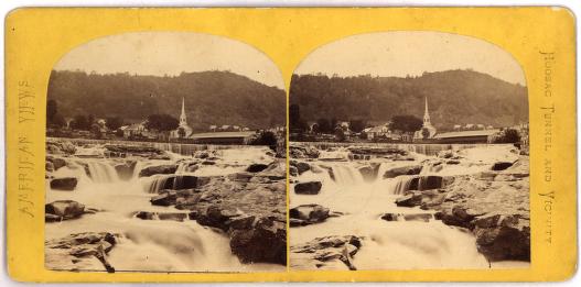
Shelburne Falls

front
(c) Pocumtuck Valley Memorial Association, Deerfield MA. All rights reserved.
Contact us for information about using this image.

First known as Salmon Falls for the salmon and shad found there, the falls were an important food source for the Native Americans and European communities in the region. During the late 18th century the falls were dammed, increasing the power potential of the water and stimulating the growth of industry. The potholes that lie below the dam began forming 14,000 years ago. During the ice age, a giant lake that is now referred to as Lake Hitchcock covered the area. Once this drained, the Deerfield River was formed. The water's action eroded the rock and formed these potholes.


top of page

Share this image with a friend.
Simply enter their e-mail address below and we'll send them this image in an e-mail greeting, along with a link to see the image on our site.

To E-Mail Address *
From E-Mail Address *
From Name
Message

* = Required


button for Side by Side Viewingbutton for Glossarybutton for Printing Helpbutton for How to Read Old Documents


Home | Online Collection | Things To Do | Turns Exhibit | Classroom | Chronologies | My Collection
About This Site | Site Index | Site Search | Feedback