Send an E-Postcard of:
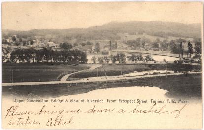
Upper Suspension Bridge and View of Riverside, From Prospect Street, Turners Falls, Mass.
(c) Pocumtuck Valley Memorial Association, Deerfield MA. All rights reserved.
Contact us for information about using this image.
The Upper Suspension Bridge, or "Red Suspension Bridge," connected Turners Falls with the town of Gill, located across the Connecticut River. The bridge was built in 1878 on the upstream edge of Turners Falls and was complemented by the Lower Suspension Bridge, constructed in 1872 on the downstream side of Turners Falls. The bridge was 550 feet long and stood 20 feet above the water level. It survived the great flood of 1936, which wiped out many other bridges on the Connecticut River in Franklin County, but after the completion of the Turners Falls-Gill Bridge in 1938 it was closed to all but bicycle and foot traffic. As a part of the World War II salvage movement, the bridge was dismantled in September, 1942.
top of page
|
|


