Send an E-Postcard of:
Mt. Sugarloaf
(c) Pocumtuck Valley Memorial Association, Deerfield MA. All rights reserved.
Contact us for information about using this image.
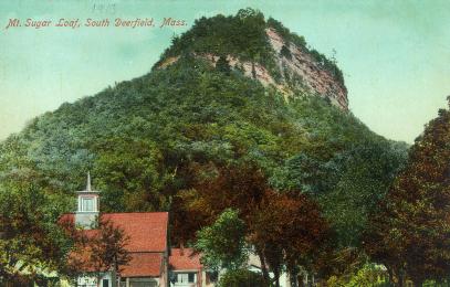
The land below Mt. Sugarloaf was the home of a number of area farmers who took their grain to the S&G Mill just below the outcropping. The mill's distinctive cupola is clearly visible to the left of this picture. The land around the mountain had been owned by the Jewett family for generations. They operated a ferry connecting South Deerfield with Sunderland, Massachusetts, a crucial east-west crossing of the Connecticut River spanned today by a bridge. These settlements by descendents of Europeans sat atop fields and home sites of earlier generations of settlers. As early as 11,000 years before the present, palaeo-Indians had settled here on the dunes left by the sudden disappearance of Lake Hitchcock. The traces of their occupation were unknown until the 1970s and unexcavated until the 1990s.
top of page
|
|


