icon for Home page
icon for Kid's Home page
icon for Digital Collection
icon for Activities
icon for Turns Exhibit
icon for In the Classroom
icon for Chronologies
icon for My Collection

Things To Do
Dress Up | 1st Person | African American Map | Now Read This | Magic Lens | In the Round | Tool Videos | Architecture | e-Postcards | Chronologies | Turns Activities

Send an E-Postcard of:
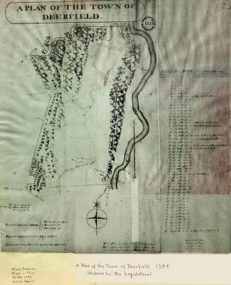
"Plan of the Town of Deerfield"

document
(c) Pocumtuck Valley Memorial Association, Deerfield MA. All rights reserved.
Contact us for information about using this image.

Hoyt's map carefully marks the boundaries of the town, shows the network of roads, and names the ferries across the Deerfield and Connecticut Rivers. At this time no bridges existed, and the Old Albany Road west of the village of Deerfield continues across the river at a ford or shallow spot in the river. The map also notes the locations of mills, and differentiates their type by symbols. The village of Deerfield appears as the sole settlement, although numerous outlying houses and farms existed at this time. Hoyt's pictorial representation of hills to the east and west dominate the landscape and give an impression of rugged terrain.


top of page

Share this image with a friend.
Simply enter their e-mail address below and we'll send them this image in an e-mail greeting, along with a link to see the image on our site.

To E-Mail Address *
From E-Mail Address *
From Name
Message

* = Required


button for Side by Side Viewingbutton for Glossarybutton for Printing Helpbutton for How to Read Old Documents


Home | Online Collection | Things To Do | Turns Exhibit | Classroom | Chronologies | My Collection
About This Site | Site Index | Site Search | Feedback