|
(c) Pocumtuck Valley Memorial Association, Deerfield MA. All rights reserved.
Agriculture : Agriculture and Community
|
|
The Puritan settlers who came to New England wished to establish close-knit communities that would be models of Christian love and purity. One of the first steps in settling a new town was to survey and lay out individual lots. Some early towns in the Connecticut River Valley such as Deerfield, Massachusetts, chose to lay out these lots in a common field system. This system dated back to medieval times in the region of England from which many of the settlers to the Connecticut River Valley originally came. House lots of three to seven acres lined either side of a main street, surrounded by common fields. Each household planted, cultivated and harvested its narrow strips of land in common with the land of other residents. All had to maintain their portion of the common fence that enclosed the fields.
Although settlement patterns differed from town to town and from region to region, these towns shared one important characteristic. Unlike most English farmers, the proprietors of these early New England towns owned the land they worked. The opportunity to own land lured many English people to the colonies, where they altered the landscape and environment in important ways. The common fence that prevented English livestock from foraging among and trampling crops disrupted the flow of game upon which the Native Americans depended for food and other necessities. Fences also restricted the free range of people across the landscape. Water-powered mills affected the flow of rivers and streams. European grasses and livestock competed with or displaced native animals and plants.
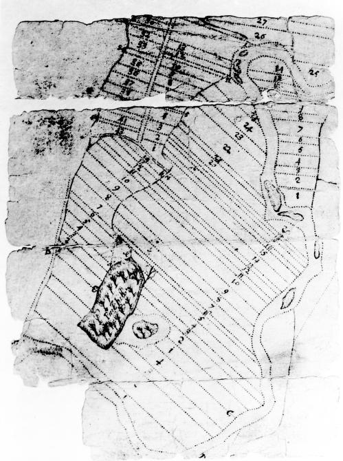
A group of proprietors living in Dedham, Massachusetts, hired a surveyor to draw a plan of Deerfield, Massachusetts. This surviving fragment shows how the land was divided into numbered lots. The amount of land proprietors received depended upon their social status, economic position and family size. The quality was evenly distributed, but the quantity varied. Each proprietor received a houselot upon which to build a dwelling. They also acquired acreage suitable for tillage, pasturing livestock, growing hay, and harvesting wood. All lots provided access to the river.
Deerfield is an example of a "frontier" town settled by people who could not afford land in the longer-settled, more secure towns in the eastern part of Massachusetts. Deerfield's exposed situation made it vulnerable to raids by hostile French and/or Indians. These dangers deterred settlement among the proprietors residing in relative safety in Dedham, Massachusetts. Most chose to sell their land rather than relocate to Deerfield.
top of page
|
Lot Survey of Deerfield
| cartographer Unknown |
| date c. 1686 |
| location Deerfield, Massachusetts |
| height 12.0" |
| width 7.0" |
| process/materials manuscript, paper, ink |
| item type Maps/Cadastral |
| accession # #L98.007 |
|


