

Advanced Search
| Online Collection |
|
||||||||||||||||||||||
|
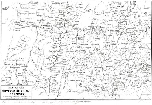
This map of central and western Massachusetts was included in Samuel Drake's Old Indian Chronicles, published in 1867. The book is primarily composed of original accounts of King Phillip's War (1675-1676), a devastating conflict between Indian groups and European settlers. Although the map is attempting to identify Indian country at the time of the war, some of the town boundaries it shows were established several generations later. For example, the map shows Sunderland, opposite Deerfield, which was not established until 1709. Drake has superimposed the names of some sixteenth century tribes and colonial forts on the map. The Nipmucks, to which the title refers, probable did not range as far west as the map suggests. Many Indians had been killed or driven from this region by 1700. Those that remained were marginalized by the dominant white culture.
|
Map of the Nipmuck or Nipmuck Country compiled from a 1774 Survey published in "The Old Indian Chronicle"
|
| |
Home | Online Collection | Things
To Do | Turns
Exhibit | Classroom | Chronologies | My
Collection
About This Site | Site Index | Site Search | Feedback


