icon for Home page
icon for Kid's Home page
icon for Digital Collection
icon for Activities
icon for Turns Exhibit
icon for In the Classroom
icon for Chronologies
icon for My Collection

Online Collection

front
(c) Pocumtuck Valley Memorial Association, Deerfield MA. All rights reserved.
Contact us for information about using this image.


label levels:

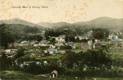
Erving, Massachusetts, is defined by the long, high ridge rising north of the Millers Falls River, with the vast majority of the population clustered in the valley of the river. The available waterpower defined the character of the town, and from the beginning it supported grist mills and a tannery. You can see the river in the foreground of this picture. The town is rural in character, and many of the buildings seen in this picture are still a familiar site.


top of page

"General View of Erving, Mass."

creator   W. B. Hale
date   Jun 13, 1913
location   Williamsville, Mass.
width   5.5"
height   3.5"
process/materials   half-tone paper print
item type   Photograph/Photograph - Postcard
accession #   #M.77


Look Closer icon My Collection icon Detailed info icon


ecard icon Send an e-Postcard of this object


See Also...

"Erving & Wendell"

Farley, Mass., Rattlesnake Mt. in Distance

"Picturesque Franklin"

Farley, Mass., Rattlesnake Mt. in Distance

"Erving & Wendell"

"The Hermit of Erving Castle"


button for Side by Side Viewingbutton for Glossarybutton for Printing Helpbutton for How to Read Old Documents


Home | Online Collection | Things To Do | Turns Exhibit | Classroom | Chronologies | My Collection
About This Site | Site Index | Site Search | Feedback