icon for Home page
icon for Kid's Home page
icon for Digital Collection
icon for Activities
icon for Turns Exhibit
icon for In the Classroom
icon for Chronologies
icon for My Collection

Online Collection

document
(c) Pocumtuck Valley Memorial Association, Deerfield MA. All rights reserved.
Contact us for information about using this image.


label levels:

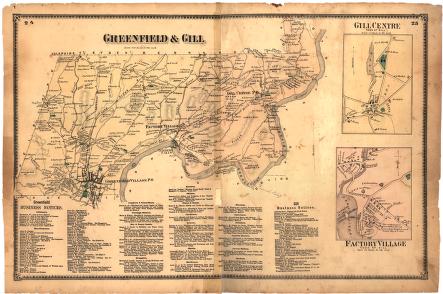
The town of Greenfield, Massachusetts, which included Gill, Massachusetts was set off from the mother town, Deerfield, in 1753. Gill then split off from Greenfield in the 19th century. When Franklin County was created from the Old Hampshire County in 1811, Greenfield with its location on three rivers (Deerfield, Connecticut, and Green), had grown significantly from its 18th century beginnings and it became the county seat. The Beers map includes physical features and names many of the major retail and manufacturing establishments present in the second half of the 19th century.


top of page

"Greenfield & Gill"

publisher   F. W. Beers and Company
cartographer   Frederick W. Beers (1839-1933)
date   1871
location   New York
width   24.0"
height   15.5"
process/materials   lithograph, paper, ink, watercolor
item type   Maps/Cadastral
accession #   #L02.012


Look Closer icon My Collection icon Detailed info icon


ecard icon Send an e-Postcard of this object


See Also...

"Statistical Information Relating to Certain Branches of Industry in Massachusetts, For the Year Ending May 1, 1865"

"Historical Collections, being a General Collection of Interesting Facts, Traditions, Biographical Sketches, Anecdotes &c.",

"Picturesque Franklin"

Upper Suspension Bridge and View of Riverside, From Prospect Street, Turners Falls, Mass.

Frontpage of Gazette & Courier newspaper


button for Side by Side Viewingbutton for Glossarybutton for Printing Helpbutton for How to Read Old Documents


Home | Online Collection | Things To Do | Turns Exhibit | Classroom | Chronologies | My Collection
About This Site | Site Index | Site Search | Feedback