icon for Home page
icon for Kid's Home page
icon for Digital Collection
icon for Activities
icon for Turns Exhibit
icon for In the Classroom
icon for Chronologies
icon for My Collection

Online Collection

document
(c) Pocumtuck Valley Memorial Association, Deerfield MA. All rights reserved.
Contact us for information about using this image.


label levels:

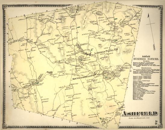
Ashfield Plains was the commercial center of the town of Ashfield, Massachusetts, but other distinct communities also arose. In the northern part of town was Howesville, named for the Howes family whose homes were distributed throughout the region. In 1871, despite a short growing season and difficult and rocky terrain, most families in Ashfield were still making a living by farming. The Business Notices on the side of the map, however, indicate that some had chosen to work with another natural resource, the forest, manufacturing lumber, chairs, and faucets.


top of page

"Ashfield"

publisher   F. W. Beers and Company
cartographer   Frederick W. Beers (1839-1933)
date   1871
location   New York
height   15.5"
width   12.0"
process/materials   lithograph, paper, ink, watercolor
item type   Maps/Cadastral
accession #   #L02.021


Look Closer icon My Collection icon Detailed info icon


ecard icon Send an e-Postcard of this object


See Also...

Farm House

"The Old Porch" Ashfield House, Ashfield, Mass.

"Picturesque Franklin"


button for Side by Side Viewingbutton for Glossarybutton for Printing Helpbutton for How to Read Old Documents


Home | Online Collection | Things To Do | Turns Exhibit | Classroom | Chronologies | My Collection
About This Site | Site Index | Site Search | Feedback