icon for Home page
icon for Kid's Home page
icon for Digital Collection
icon for Activities
icon for Turns Exhibit
icon for In the Classroom
icon for Chronologies
icon for My Collection

Online Collection

front
(c) Pocumtuck Valley Memorial Association, Deerfield MA. All rights reserved.
Contact us for information about using this image.


label levels:

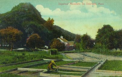
Below Mt. Sugarloaf, a farmer tends his crops. South Deerfield, Massachusetts' position along the Connecticut River meant that the periodic floods deposited some of the richest soil in the northeast onto lands adjacent to its banks. Behind the farmer, tall poles stand for the summer's snap bean crop as he tends to his strawberry beds. By the turn of the 20th century, reliable rail transportation meant that farmers were able to send crops to far-away markets that in previous years would have been entirely dependent on local produce. Behind him, the S&G Mill with its distinctive cupola stood ready to grind the fall's harvest.


top of page

Mt. Sugarloaf with farmer

creator   null
photographer   Forrest L. Stetson's Electric Print
date   1910
location   South Deerfield, Massachusetts
height   3.5"
width   5.5"
process/materials   paper print
item type   Photograph/Photograph - Postcard
accession #   #1997.08.01.0081


Look Closer icon My Collection icon Detailed info icon


ecard icon Send an e-Postcard of this object


See Also...

"Sugar Loaf Mountain"

Mt. Sugarloaf

Mt. Sugarloaf

Mt. Sugarloaf

Mt. Sugarloaf

Tent Tobacco Fields from Mt. Sugarloaf


button for Side by Side Viewingbutton for Glossarybutton for Printing Helpbutton for How to Read Old Documents


Home | Online Collection | Things To Do | Turns Exhibit | Classroom | Chronologies | My Collection
About This Site | Site Index | Site Search | Feedback