(c) Pocumtuck Valley Memorial Association, Deerfield MA. All rights reserved.
Contact us for information about using this image.
| label levels: |
 |
 |
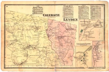
There is currently no available "Beginner" label. The following is the default level label: This map of Colrain, Massachusetts, retains the spelling used in Colrain's Irish namesake, "Coleraine." By the 1890s the "e's" had disappeared. Of all the northern tier of towns in Franklin County, Colrain was the most industrialized. This was relative, however, as none of the other towns had much in the way of industry. But the factories in Foundry Village and Griswoldville shown here employed several hundred workers, a high concentration compared to its neighbors.
By 1871, Leyden, Massachusetts, was in the midst of a long decline. Its population was half of what it had been in 1800. In an effort to compete, the citizens of the town organized the "Cheese Factory" shown in Leyden Center, but it only lasted two years; it has been, however, immortalized on this map. The factory was intended to collect milk from around the town to make a product easily transported to distant, more profitable markets. Near the southern edge of the town, in 1870, the Greenfield Aqueduct Company built a dam across Glen Brook. The aqueduct was the first to supply Greenfield with water from outside the town's wells or springs. In 1905, another dam was built above the first, and until the 1960s they supplied Greenfield with its water. This map also shows the pre-1886 border of the town: that year, Leyden signed over a segment on its southeast side to Bernardston.
top of page
|
"Coleraine/Leyden"
| publisher F. W. Beers and Company |
| cartographer Frederick W. Beers (1839-1933) |
| date 1871 |
| location New York |
| height 15.5" |
| width 24.0" |
| process/materials lithograph, paper, ink, watercolor |
| item type Maps/Cadastral |
| accession # #L02.004 |
 Send an e-Postcard of this object Send an e-Postcard of this object
|


